Trip report time!
We didnt make it as far on Friday as I was hoping for, mostly thanks to unpreparedness. After making a stop for groceries, a stop for some extra gear, and a stop at the 'flower' store.. we had to set up camp Friday night a little short of where our mapped route actually began.
Camp on Friday night was nothing special.. just a little clearing in the middle of the woods, on a dirt road that stretches between Byron and Andover. No water.. no real view.. just an assload of various biting insects and a bunch of ATVs ripping by lol. The dew point was terrible.. around 75°.. as soon as the sun started to set everything got soaked.
Saturday morning in camp:
I took a panoramic shot of camp and the clearing but it won't upload..
We packed up and hit the road..
Scenic outlook on top of Height of land in Rangely, mighty close to the start of the actual route. This is on Rt17, If you miss it.. your blind.
Once we got to the head of our route... things didn't start off well. Got a few miles in just to turn around and head back towards Rt16 because that particular road got WAY too grown in for the comfort of my paint

I knew this was going to be a potential, so I had an easy reroute mapped out and we took that instead.
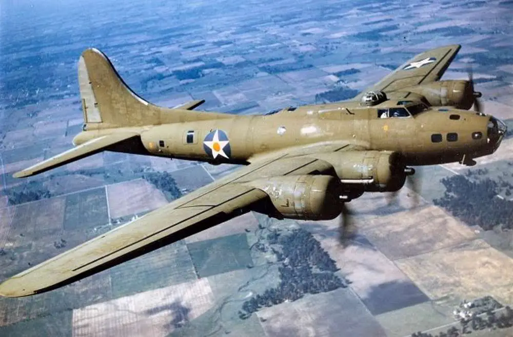
Not long later we came to the B-17 memorial:
On July 11, 1944, two planes crashed in Maine within four hours of each other. The first was the worst in Maine's history. So was the second.

newenglandhistoricalsociety.com
^ you can read a little about this wreck and another wreck that happened in Maine a few hours later here. Should also be able to zoom in on my photos and read the stone & placard.
A good portion of the fuselage is reportedly still there, and we tried to find it with no real luck. A little trail goes down over the hill (mountain) from the memorial stone.. presumably to the rest of the wreck.. but its SUPER grown in. We needed to crouch below the waist-high undergrowth to be able to see where the trail went.. and eventually came face to face with a pile of fresh bear scat. I wasn't carrying lead heavy enough to throw at bear, so we turned around.
It started getting dark&stormy looking considering the weather said it was supposed to be nice all weekend

Crossing the bridge over this stream WAS the plan, until we got there and saw that it's been removed... so... started another detour.
We backtracked awhile and got to the start of the road that's on the other side of the pictured stream.. and started our way north.. just to be met with a locked gate -__- more backtracking, more detours. This one was a real bummer.. the section of our route that was gated off ran right beside the Canadian border and had a big cluster of ponds that would of been really nice to see.
We emerged from the woods in Eustis, right around dinner time. Rain had started. I had hoped to be to this point many hours prior.. stupid detours.
We were hungry, I was bummed about the day, didn't want to search for a place to set up camp.. and certainly didn't want to get wet.. so i decided to cheat and get a room at a local motel

ended up being the right decision. That storm caused all sorts of havoc back home.
The following morning.. BEAUTIFUL day.. temperatures were 20 degrees cooler than the previous two and nearly all the humidity had vanished.. actually needed to wear a sweatshirt all day lol.
On the road again..
2nd leg of the trip starts out passing by "a" windfarm.. if you zoom in you can see a dozen or so turbines in the distance.. there were a handful of them behind where I was standing.. and off to the right and further to the left there are probably another dozen or so. IIRC the top of this mountain was 3500' or so.. highest point all weekend.
We crossed over an incredible amount of super picturesque little mountain streams.. really would of liked to stop and enjoy them all.. but would of needed a week off at minimum lol.
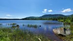
Rock pond.. unknown town.. id have to check the map. There are a couple primitive campsites here that we want to stay at eventually. Super gorgeous.. and full of 100% wild unstocked trout.
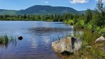
Brook that dumps into Rock pond.. one of the sites is immideately to the left of where I took this (top) picture.
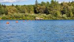
(The site is directly to the right now) One of the coolest primitive spots we came across for sure... thanks to one presumably man made feature. This is your typical rocky mountain stream.. average depth probably less than a foot... BUT...
The little bit circled in blue is probably 5' deep. JUST right there. Nice spot to sit and soak on a hot day.. a HOT day... mountain streams are NOT warm lol.
Also got to experience some real NatGeo stuff while we were standing by the pond.. just hanging out.. enjoying the silence.. all of a sudden a huge commotion erupts from the grass and up comes this GIANT dragonfly with a meal that wasn't that much smaller than it was... super brutal. It was hungry enough where I could get my phone within range to get some decent pictures and a video..
I enjoy trees growing around things.. Definitely appreciated this sign.
We were almost to the 2nd and final paved portion of the trip when we came to this road.. barely there. Went about a mile or so down here and decided to turn around when it started to get even more grown in and wet... another detour... oh well.
Took the paved road through Jackman, and back into the woods.
Ended up in the area of Seboomic for dinner and our final night.. nestled between Seboomic lake and the north bay of Moosehead lake.. gorgeous area. We stayed at a lean-to site just above Seboomic dam... we were kept good company by some random dead guy. Trying to find info on the grave.. not much luck so far. There might not be any... or anyone still living that knows info about it.
Almost all the safety bouys had some sort of Crane camped out on it the whole time we were there. Good fishing. Saw & heard a few loons as well.
There was a relatively new outhouse across the road.. well ventilated.
Our last night.. tried out night mode on my phone.. meh.
That pretty much wraps it up... between our late start on Friday and a whole day of detours & reroutes on Saturday... we only got to mabey 50% of the mapped route. To do the entirety of the route, with plenty of time to stop and enjoy the nature along the way.. probably 4 days minimum.. mabey a week? The last half of the trip had some cool stuff too... ice caves and some abandoned trains used for logging 100 years ago. Can't wait to get there.