- Joined
- Feb 15, 2020
- Messages
- 5,503
- Reaction score
- 6,359
- Points
- 113
- Location
- Southern maine
- Vehicle Year
- 2023
- Make / Model
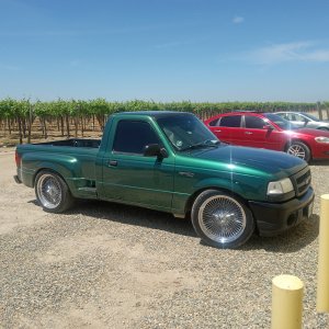
- Ford Bronco
- Engine Type
- 2.3 EcoBoost
- Engine Size
- 2.3
- Transmission
- Automatic
- 2WD / 4WD
- 4WD
- Total Lift
- 2.5"
- Tire Size
- 285/75/18
- My credo
- Its probably better to be self deprecating than self defecating.
I am in the budding stages of planning an overland adventure for myself and my fiance across our home state. This thread will be it's story.
The main goal of the trip is to cross the state on as little pavement and possible.
The goal was pretty easily realized. Considering the literal majority of land in our state is a privately owned working forest, we have nearly as many miles of dirt roads as paved.
The dirt roads come in a few flavors up here, somewhat passively defined by delorme/garmin in the gazetteer:
Local/logging roads- a hefty percentage of the dirt roads "up north" are used year round by countless logging outfits, therefore they are of decent width and they stay pretty well maintained. Vigilance while traveling traveling these "main" roads is a must. You are a guest on their over 10 million acre jobsite, they always have the right-of-way, and they're always doing 60mph... so you best stay the hell out of the way.
Unimproved roads- these are mainly seasonal roads, utilized as snowmobile trails in the winter. Sometimes they connect two "real" roads or state routes, often times they dead end you at some remote pond, up a mountain, in a bog, or just in a clearing. The majority of these roads were originally scratched in for logging, but aren't active. Lots and lots of private camps off these roads. Not frequently maintained, but usually passable for something with more clearance than a car.
Undefined or unidentified roads- honestly, I havnt had a lot of experience with these. They aren't maintained, pass at your own risk. A good number of them are gated off, or would likely require 4x4. My route doesn't rely on these, but for scientific purposes I'm gonna find out "what their deal is"
The proposed route (purple line):
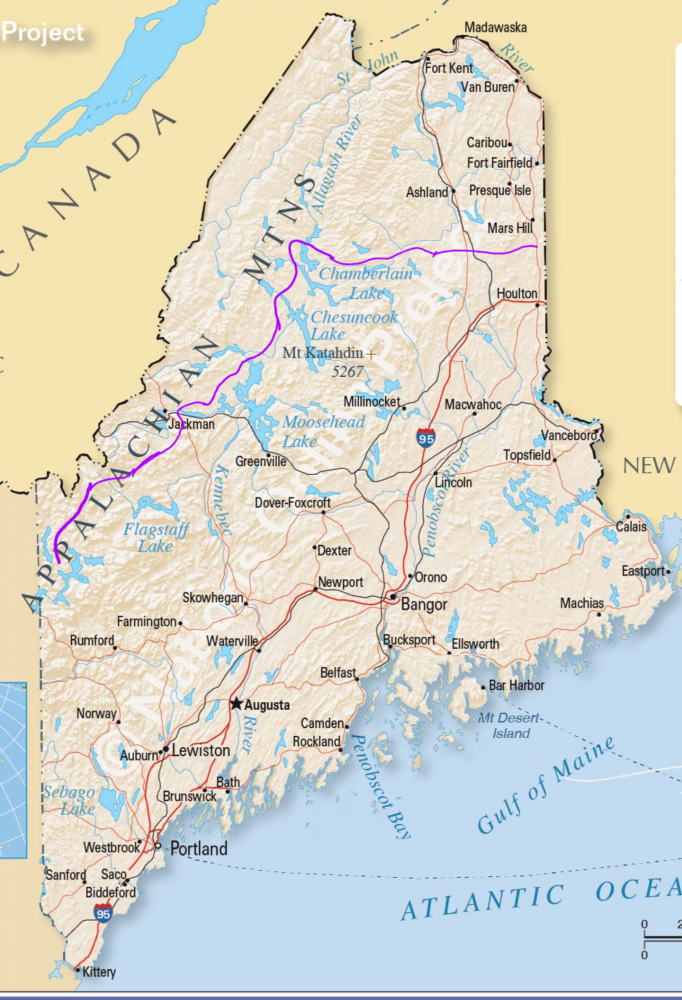
We'll start our journey a couple hours north, just west of rangely, just east of NH. The route will take us northeast through the Appalachian mountains, above Baxter&Katahdin, and clean over to our border with new Brunswick.
Main points of interest are a wrecked b-17, ice caves, and abandoned trains. Apart from those, well be passing an absolutely staggering amount of lakes/ponds/rivers/streams (maine has over 8000 named bodies of water), countless mountains, and hopefully only a handful of other people.
My eyes are real tired of staring at the gazetteer currently, so I havnt figured out total distance yet (guessing 300ish) When I do, I'll attempt to also count the number of mountains&bodies of water well pass.
Well be sleeping in a glorified plywood box were going to build thatll sit on my flatbed. Construction of that will begin when my flatbed is done.
Only gear that needs to be bought is a little more recovery stuff, a hatchet, hi lift jack, full size spare, and cans for gas&water. Good thing I love buying gear!
Suggestions for gear or anything else always appreciated.
The main goal of the trip is to cross the state on as little pavement and possible.
The goal was pretty easily realized. Considering the literal majority of land in our state is a privately owned working forest, we have nearly as many miles of dirt roads as paved.
The dirt roads come in a few flavors up here, somewhat passively defined by delorme/garmin in the gazetteer:
Local/logging roads- a hefty percentage of the dirt roads "up north" are used year round by countless logging outfits, therefore they are of decent width and they stay pretty well maintained. Vigilance while traveling traveling these "main" roads is a must. You are a guest on their over 10 million acre jobsite, they always have the right-of-way, and they're always doing 60mph... so you best stay the hell out of the way.
Unimproved roads- these are mainly seasonal roads, utilized as snowmobile trails in the winter. Sometimes they connect two "real" roads or state routes, often times they dead end you at some remote pond, up a mountain, in a bog, or just in a clearing. The majority of these roads were originally scratched in for logging, but aren't active. Lots and lots of private camps off these roads. Not frequently maintained, but usually passable for something with more clearance than a car.
Undefined or unidentified roads- honestly, I havnt had a lot of experience with these. They aren't maintained, pass at your own risk. A good number of them are gated off, or would likely require 4x4. My route doesn't rely on these, but for scientific purposes I'm gonna find out "what their deal is"
The proposed route (purple line):
We'll start our journey a couple hours north, just west of rangely, just east of NH. The route will take us northeast through the Appalachian mountains, above Baxter&Katahdin, and clean over to our border with new Brunswick.
Main points of interest are a wrecked b-17, ice caves, and abandoned trains. Apart from those, well be passing an absolutely staggering amount of lakes/ponds/rivers/streams (maine has over 8000 named bodies of water), countless mountains, and hopefully only a handful of other people.
My eyes are real tired of staring at the gazetteer currently, so I havnt figured out total distance yet (guessing 300ish) When I do, I'll attempt to also count the number of mountains&bodies of water well pass.
Well be sleeping in a glorified plywood box were going to build thatll sit on my flatbed. Construction of that will begin when my flatbed is done.
Only gear that needs to be bought is a little more recovery stuff, a hatchet, hi lift jack, full size spare, and cans for gas&water. Good thing I love buying gear!
Suggestions for gear or anything else always appreciated.
 now I won't need to worry about it. Should have enough power on one charge to keep the food cold for the weekend.. super excited to try it out!